
When Drone Photography Is Worth It for Real Estate Listings

Discover when drone photography real estate makes the most impact, helping your listing stand out with aerial views that highlight key property features.
Why Real Estate Media Matters
Deciding when to invest in drone photography real estate often comes down to whether an aerial view truly helps present the unique features of a property. Agents and marketers in NYC and New Jersey frequently ask if an overhead perspective will add useful context or if traditional ground-level photos will suffice. The right choice depends on the story the listing needs to tell and what potential buyers might want to see at a glance.
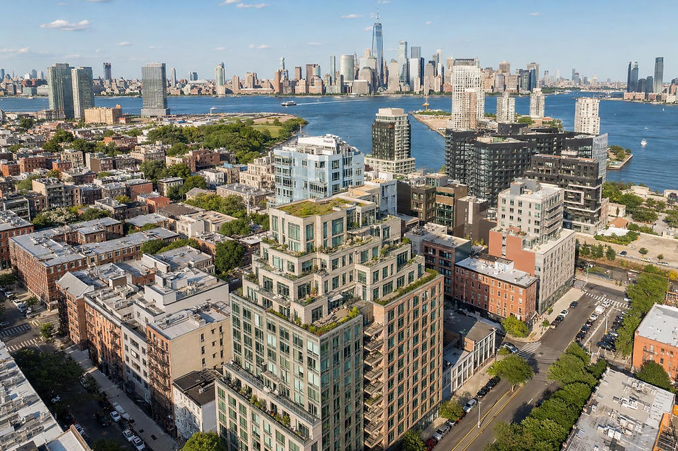
For many listings, showing the relationship between a property and its surroundings—such as lot boundaries, outdoor amenities, views, or nearby green spaces—can be a real advantage. Interior photos may highlight the rooms, but they can't always answer questions about outdoor space, a waterfront edge, or how a building sits within its neighborhood. Aerial property photography becomes valuable when those bigger-picture elements are central to the appeal.
However, not every property needs an aerial view to make an impact. Homes in dense areas like Manhattan or Brooklyn sometimes leave little room for a drone to operate, and what is visible from above may not contribute much to the listing. The decision is more than whether drone images are impressive; it's about whether they clarify something meaningful to a likely buyer.
Video, 3D Tours, and Visual Storytelling
The most effective real estate drone photography addresses questions buyers might ask before scheduling a visit. Does the lot have unexpected depth? Is there a unique roof deck or a clear connection to local parks or waterfronts? Can exterior amenities be shown together in one concise view? When a listing stands to benefit from these perspectives, drone media can add real value.
Properties with sizable land, private yards, distinctive outdoor features, or architectural details that are hard to capture from street level are especially strong candidates for aerial media. In suburban New Jersey, for example, a bird’s-eye photo can reveal privacy, orientation, a backyard layout, or how amenities relate to each other, helping buyers understand the full offering before they visit in person.
Waterfront, river, or lake properties are another situation where aerial images can make a difference. A drone can show the distance to the shore, boat access, neighboring homes, or the bigger water view in ways ground photography usually cannot. For these listings, it’s not about dramatizing the setting, but providing an honest, contextual view that supports a buyer’s decision.
Why Agents Choose RealtaSnap
Distinctive architecture, such as layered rooflines, hillside homes, or estate properties, often benefits from a higher perspective too. Aerial images can highlight scale, the relationship between buildings, or showcase a dramatic setting that’s tough to appreciate from the sidewalk. Even smaller homes can stand out if an overhead shot reveals a notable outdoor space or unique lot shape.
Developers and commercial marketers often use aerial photography to explain the full scope of a property. An overhead image can clarify parking, site boundaries, access points, and proximity to amenities before showing details of model units or interior spaces. For multi-building properties and larger commercial sites, these views can make layouts and infrastructure clear at a glance.
That said, there are times when aerial media offers little advantage. If a property’s outdoor space is minimal, surrounded by taller structures, or if key features are better shown from ground level, drone photography may not add value. For city apartments, especially those with no private outdoor access or distinctive rooftop, focusing resources on strong interiors and floor plans is generally the better call.
Fast Turnaround and Better Results
Drone flight feasibility is always a practical concern, especially in busy urban areas. RealtaSnap evaluates each location based on airspace, safety, access, local restrictions, weather, and pilot judgment before confirming an aerial shoot. Not every property is flyable, and permission is never guaranteed prior to a full site review.
In Manhattan and Brooklyn, aerial property photography is managed on a case-by-case basis. Roof access, nearby structures, pedestrian activity, and city rules all affect what’s possible. For penthouses or townhouses with accessible rooftops or remarkable views, drone work may be feasible; otherwise, street-level photos and video may be both safer and more effective.
RealtaSnap serves NYC and New Jersey with marketing-focused drone photos and video for approved listings. Their approach starts with analyzing the property’s true features and the practicalities of flying at each site. When aerial coverage is appropriate, it is scheduled alongside other listing media so photography, video, and aerials fit together to tell a cohesive property story.
Before choosing drone services, it’s worth considering what will be most helpful for buyers. Look for standout exterior features, unique lot relationships, or settings where an aerial view answers questions ground photography cannot. All prices and information are subject to change. Information is deemed reliable but not guaranteed.
Ready to Elevate Your Next Listing?
Ready to get started? Visit RealtaSnap to explore our services and book your next shoot.
Frequently Asked Questions
Does every property benefit from drone photography?
Not all properties gain from aerial media. It’s most useful when the land, outdoor features, or setting are important and can’t be fully shown from ground level.
How is drone flight approval determined for city listings?
Drone flights are reviewed individually with attention to airspace, roof access, local restrictions, safety, and other site conditions before approval.
What’s the difference between aerial photos and aerial video for listings?
Aerial photos are useful for clear, flexible gallery images, while aerial video can provide motion, context, and a sense of setting for buyers, depending on the marketing plan.


Comments